
What a Randolph County Property Value Means
A Randolph County assessment card can show land, building, other and total appraisal fields. It also includes a sale-history row. Each figure means something different. The assessed or appraised amount is the Assessor's tax-roll number for one tax year. A last-sale amount documents a transaction that already happened. Market value is a current estimate of what a willing buyer might pay. Neither the assessment nor one past sale guarantees it.
| Value | What It Is | Where |
|---|---|---|
| Land appraisal | Land component displayed on the assessment card | WV Property Assessment |
| Building appraisal | Improvement component, which may be zero on a vacant or exempt sample | WV Property Assessment |
| Total appraisal | Card's total for the displayed tax year | WV Property Assessment |
| Last sale history | Past consideration and sale details when available | Assessment history / recorded deed |
No Randolph-specific assessment ratio or market-value formula appears in the county's published materials. Read the card's stated fields as displayed. Ask the Assessor how the current amount was set. A past sale adds context. It is not a current appraisal or a guaranteed comparable.
Randolph County Appraisal Fields on the Sample Card
The sample parcel card shows tax year 2026, a land appraisal of $20,500, a building appraisal of $0 and a total of $20,500. Tax Class 3 appears on it. So does the land-use description "600 Vacant Exempt Land." Deeded acreage is 0.198, with calculated acreage of 0.20. These values come from one card, not countywide averages or a rule for other parcels.
A sales-history entry on the same record lists December 1, 1998, at $24,618 for land and buildings. That amount belongs to that date and that transaction alone. It cannot stand in for current market value. The exact legal interest or condition at that sale belongs in the deed, so check the deed records before drawing conclusions.
Randolph County Assessment Detail and Parcel History
The card carries a formatted Parcel ID, owner display, mailing and physical addresses, legal description, appraisal components, flood display and parcel history. Sample history rows run annually from 2006 through 2026. Compare values by the year column. An old amount is not today's tax-roll value.
The West Virginia parcel detail for Randolph is the source for the example, and its official page displays all these fields together.
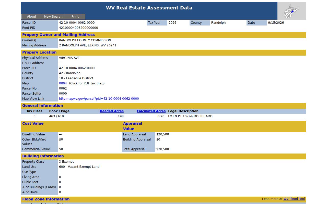
An Owner(s) row can show a single name even where several owners exist. The mailing address and physical address are separate fields, so read neither one as a valuation fact.
Deeded and Calculated Acreage in Randolph County
The Assessor card may place deeded acreage and a GIS-calculated figure side by side. On the sample parcel they are 0.198 and 0.20 acres. The Viewer describes calculated acreage as an estimate drawn from map geometry. It is not legally recognized acreage. Deeded acreage controls assessment. The gap can shape how a reader reads land value per acre or compares parcels.
An acreage dispute calls for the deeded description and a survey, not the map. The map-derived figure is a planning clue at best. A land appraisal also rests on the Assessor's full property records. It does not rest on just the acreage on screen.
Randolph County Tax Class and Value Context
The sample carries Tax Class 3 and the land-use phrase "Vacant Exempt Land." No current Randolph exemption list, eligibility table or assessment-ratio percentage is published alongside it. So the example should not be generalized to other owners or parcels. Ask the Assessor about the exact class and land-use code on the card.
A tax class is a classification on the record, not a sale-price measure. Property tax questions split between offices. The Sheriff and the Assessor each provide different records. The Randolph County property-tax records page covers the bill calendar and account path.
Randolph County Assessment Ratio Is Not Published Here
The county publishes no assessment ratio or local reassessment cycle for Randolph County. Do not apply a ratio borrowed from another West Virginia county. Never infer one from a single parcel card either. The state assessment system shows annual tax-year fields and historical rows. Yet it does not state how often a particular parcel is revalued.
For a formal explanation, contact the Assessor at 304-636-2114 with the parcel ID and tax year. Ask whether the value field reflects a recent review. Ask which comparable data was used. Also ask how to request correction or appeal under the current local process.
Find a Randolph County Property Value on the Card
The state assessment search covers Randolph County. It accepts owner, street name, parcel, district, and map fields, so try the street name alone if a full address fails. Then check the physical address against the legal description. For a value question, note the tax year and separate the land, building, and total appraisal before comparing the entry to any sale record.
Advanced filters narrow results further. You can set a minimum or maximum for land, building, and total appraisal, or filter by calculated or deeded acres, sale date, sale price, class, and flood hazard. That makes it easier to line up comparable tax-card entries. The county publishes no appraisal ratio or revaluation cycle. Record the tax year and parcel description for each comparison rather than treating a filtered list as a market-value estimate.
- Search Randolph County by street name, owner, parcel ID or district and map.
- Open the correct card and record its tax year, land appraisal, building appraisal and total.
- Review parcel history and any sale-history row as dated data points.
- Use the deed record for the transaction and a licensed appraiser for a current market opinion.
- Assessment appraisal
- The value entry shown for a tax year on the state card.
- Market value
- A current estimate, not guaranteed by the tax record.
- Sale consideration
- The price or amount recorded for a past transaction.
- Reassessment
- A review that could change a record value; the local interval was not verified.
A Randolph County Sale Price Is a Past Event
That $24,618 sale entry is dated December 1, 1998. The amount and date describe an old transaction. They say nothing about today's market. Condition, improvements, parcel size, land use, and the buyer's terms may all have changed since that transfer. A recorded sale can anchor a timeline. Still, it is one data point, and it should be checked against the deed reference.
The tax card's annual appraisal history is not a verified sale price. Don't confuse the two lines. When a current market value matters for a transaction, ask a licensed appraiser. The County Clerk's deed records can confirm the filed conveyance, and the assessment card supplies the tax-roll figures.
The card's annual parcel rows run from 2006 through 2026, while the cited sale occurred in 1998. Those dates mark different record events. Read the older transfer by its deed reference. Place the appraisal period by its tax year, since neither entry supplies a present-day market appraisal.
What a Randolph County Assessed Value Cannot Tell You
The assessed value on a Randolph County property card serves the tax record. It promises nothing about what a buyer will pay. It is neither a current appraisal nor a title conclusion. A number can reflect a prior assessment year. A recent sale or improvement may not yet show in the roll. Check the record date before you conclude anything. Compare the land and building components, the sale-history date, and the legal description. Then decide what the assessed value really supports.
Value vs. price. The Randolph County assessment figure does not tell what the property will sell for. Obtain a current appraisal for a sale or lending decision.